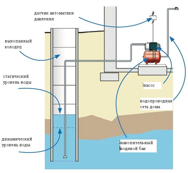
How deep does an artesian well start?
In the generally accepted sense, an artesian well in the Moscow region is a well drilled to water-bearing limestone, hence its second name is a limestone well. But at what depth the drillers will open these limestones, this will be the very “optimal well depth”. Water may also be contained in other rocks, but in the Moscow region they are drilled into limestones. Since the geology of the area is heterogeneous, such aquifers can occur both at 20 meters and at 200 meters. And no one can accurately say the exact depth of their occurrence.
Having opened these rocks, you will get a well with a certain flow rate (productivity). A submersible pump is selected for this flow rate and for your goals, and then it does not matter whether this water is used for irrigation or for the home, the pump will pump as much as it can.
For a more accurate understanding of what to expect in your area, you should look at the map of the depths of the Moscow region or return to and use the advice from there. If you are not in the Moscow region, find a similar map of your region and find out how deep water wells are drilled in you, but all these are only indicative values.
Well water level measurement
After the well has been drilled, the water level in the well is measured with a device that drillers call a cracker. When it hits the water, it emits a pop, this allows you to determine the static level of the water.
The dynamic water level is defined differently: when water is pumped out, it bounces on the rods, the underwater and surface parts become slightly different colors. Based on this, it is easy to determine the dynamics.
You can’t throw a cracker, even if the well is large in diameter and the pump is narrow, there is a risk that everything will get stuck.
All these works are carried out by drillers, you yourself do not need to measure the water level, especially since the pump is already standing. There is a very high chance of the gauge getting stuck, and repairs are very expensive. Yes, and it makes no sense to remeasure, everything has already been done and calculated for you.
Requirements for the location of the well
Before starting drilling, the selected location must be assessed in terms of suitability for the construction of a well for the production of drinking water. At a distance from it within a radius of at least 50-100 m, sources of pollution, such as cesspools, garbage dumps and manure heaps, cannot be located. You should not plan the location of the well closer than 3 m to a residential building, otherwise it may be difficult to operate a drilling rig and dig a trench for water pipes.
The slope of the surface at the point of drilling cannot be higher than 35°. The drilling mast requires a free height of about 10 m and a horizontal area of at least 30 sq.m. In the immediate vicinity of the drilling site there should be no electrical wires and other interference that may be unsafe for the upcoming work.
Well depth and type of lifting equipment
Not that the depth of the water well depends on how you are going to raise the water up. Rather, on the contrary, the equipment has to be selected depending on the dynamic water level, above which the depth of the pump immersion in the well should not be. How to calculate the level based on the power of the pump and the flow rate of the source is a separate topic, the materials can be found on our website. The dynamic level can be determined practically by measuring it in the dry season, actively watering the garden. So, the equipment:
Gate or "crane" - manual lifting: twist faster and pull harder. The deeper, the more physical effort you have to spend.
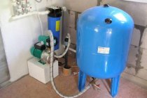
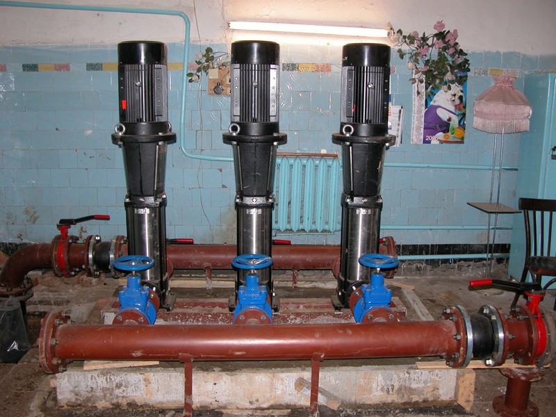
A complete water station, including a pump, a hydraulic accumulator and the necessary automation, is a good thing, inexpensive, and easy to maintain. Only the hose is lowered into the water, the pump is placed on the surface. Unfortunately, the station is able to raise water from a depth of only 8-10 m, no more.
 Scheme of installation of a waterworks with a surface pump. The station is best placed in the house
With a lifting height of more than 10 m, you will have to use a submersible pump. A cheap vibrating "Stream" or its analogues have a lifting height of 40-60 m, which is more than enough.
 Installation option for a submersible pump with a summer water supply outlet
Centrifugal submersible pumps are more expensive, but more powerful and capable of pumping water under significant pressure. They should be preferred if a pressurized water supply is planned in the house using a hydroaccumulating tank. Most submersible pumps are designed for installation in a narrow well and have a small diameter, which complicates their design and reduces the ability to cool. There are special pumps for wells, they are better cooled, have a wider body and are somewhat cheaper.
A well submersible pump is cheaper than a borehole pump, its body is wider. It just won't fit in the well.
By the way, the height of the well pump is much lower than the well pump, which is important for sources with low water levels.
And yet, to what depth should the pump be lowered into the well? The minimum, as we have already mentioned, is the dynamic water level. The maximum is half a meter from the bottom of the well. There are models that can be installed on the bottom, if specified in the instructions.
As you can see, there is no universal answer, what should be the depth of the water well near your house. And it cannot be. Finally, we repeat once again that the construction of a well is not an easy task and is associated with a certain risk. If you do not have knowledge and experience in this area, it would be wiser to entrust such work to professionals.
Well Depth Measurement Technology
In order for the definition of the parameter of interest to be accurate, you should have:
Tools for measuring the well: a cord with a load and a building meter.
- well passport;
- pump or motor pump;
- ruler or construction meter;
- cord;
- metal cargo.
If, nevertheless, the well was organized to order, then there will be no problems with the passport, since the working team issues it without fail. The first step is to read the document. Each company can have an individual filling form, but with certain standard indicators:
- the depth at which the aquifer is located;
- well depth;
- casing diameter parameter;
- indicator for the level of the aquifer.
From such a data sheet, you can take measurements of the depth of the well. But this document will only be available if the drilling was done professionally.
But with independent work, such a passport will be absent. But you can also deal with this issue on your own.
Measurement works are as follows:
Measuring the depth of the well with a special reader.
- To measure the depth of the well, a prerequisite is good dry weather, preferably at the end of summer. It is during this period that the groundwater level is at its lowest level.
- The ruler is used to measure the diameter of the well. Next, a load is tied to the end of the rope, which is lowered into the well. The descent must be carried out until the cord releases tension, that is, when the load touches the ground. After that, the measuring device is taken out. The level at which the rope is no longer wet is the height of the water, and the dry side indicates the statistical depth of the hole. Next, using a ruler, measurements of both parts are made. You can simplify the task.Before lowering the measuring cord into the well, colored tapes are attached at regular intervals, counting which you can determine the depth of the well.
- You also need to know the dynamic depth. This will require a pump. The suction hose goes down to the very bottom, only initially it is necessary to put on a strainer at its end, which will prevent clogging.
- Next, the device turns on, after which time is expected until it pumps out all the water. When a characteristic squelching sound begins to be heard, which will indicate the completion of pumping, the pump turns off. After that, the measuring cord is lowered again into the remaining water. This indicator will mean the dynamic level.
This method is suitable for wells with an approximate depth of not more than 10 m. It is recommended to write down all the obtained indicators on paper, so you can make a home-made passport for the well.
It is important to know the depth of the well so that in the future it will be possible to purchase an appropriate pump that would work properly with this particular well. Diagram of the location of aquifers
Diagram of the location of aquifers.
In each locality, the level of aquifers can vary significantly.
If recently drilling work was carried out in the nearest territory, then the depth of deposits of such layers can be found out from the workers. Although there is no guarantee that a well with drinking water in one and the other area will have the same depth.
There are always several layers of water in the ground, but you should be aware that not every one of them can be used in everyday life. For example, "upper" water often does not meet sanitary standards.
The first layer is usually located at a depth of 4-6 m. And a special sanitary examination will help determine the quality of the water, whether it can be used for everyday needs and whether it is acceptable in the diet. Most often, the first layer is not intended for operation.
The second layer can be found in the range from 10 to 18 m. It is this depth of the well that is suitable for extracting suitable water.
If for some reason the second level cannot be put into operation, then it is the turn of the third layer. Its average depth is 25-40 m.
Most wells are not drilled below the 50 m mark, as this level is quite sufficient to extract usable water. Although in a separate area a suitable aquifer can be found below 60 m.
Well construction process
After all the work on the preparation of equipment and material for the construction of the well has been completed, they proceed to drilling. Carrying out work:
- For such work there is an instruction. All available tools are used: shovels, crowbars, buckets, etc.
- Initially, a depression is dug on the surface with a diameter of at least 1 m and a depth of 50 cm.
- Then a hand drill is inserted in the center and they work until it becomes difficult to pull out the earth.
- After that, you need to use the drill columns. Only a few people can turn their valve. One cannot do this kind of work.
- The principle of operation of the drill is that it is able to push the soil to the surface
- Drill to the desired depth until water appears.
- Then it is pumped out with the help of pumping equipment.
- Then the water is collected again and its quality is checked.
- After that, filtering equipment is installed and performed.
The video in this article shows the process of drilling a well. You need to drill a well in one day.
Otherwise, there may be structural collapses, and all work will have to be done again, but in a different place.
Well depth is considered an important parameter. In many ways, it is he who determines the cost of the drilling work carried out and the quality of the resulting fluid. Most often, the desire to correctly determine the amount of payment for drilling forces customers to calculate this indicator.For each additional meter they have to lay out quite real amounts.
With independent work, the distance from the water surface to the surface of the well will be required for the correct selection and installation of pumping equipment.
How to check the depth of the well after drilling? Professionals most often know the approximate level of passage of aquifers even before work is carried out. They determine it on the basis of the geological map of the territory. In other cases, this size is found out after the drilling of the object is completed. For this, several methods are used. The difference between them lies in the degree of complexity, accessibility and level of accuracy.
The most simple and affordable way is mechanical. It will require only a cord, a metal weight and a tape measure. The load is tied to a cord and gently lowered down until the tension is relieved. After that, the home-made device is removed and the size of its wet area is determined using a tape measure. This value is the depth of the well. To measure in this way, it is recommended to use a special hydrogeological tape measure. It is a flexible ruler with an attached weight at the end.
The disadvantages of this method include the inability to measure the dynamic water level. Using this method, it is allowed to measure structures with a depth of not more than 10 m.
The magnetic method is considered the most popular when determining the depth of the well. It provides accurate information about the location of deep aquifers.
The method is to use a spool of logging cable with magnetic marks. The principle of its operation essentially coincides with the mechanical one, but is improved by the presence of a reader. Magnetic marks are applied to the tape at certain distances. They are processed by the receiving device. As a result, accurate information about the location of the cargo is obtained. In the intervals between the marks, the depth is determined using a special roller located on the coil.
Aquifer level when drilling a well
The depth level of the future well (artesian or sandy) is determined both by the depth of the groundwater layers and based on the tasks that the planned hydraulic structure will perform (irrigation, technical purposes, consumption). The fact that marshes, industrial enterprises, burial sites, farmlands, often treated with pesticides and pesticides, are located next to the planned well is also important.
Formed on the basis of sedimentary and melt water, the aquifer closest to the surface is called perched water. The depth of its occurrence is no more than 5 meters. It is traditionally categorized as an unstable source, as prolonged drought or low winter temperatures can cause such water to "leak".
As for the water quality of the perch water, it is very low, containing a significant number of undesirable impurities and microorganisms that enter the water from the soil surface. However, if necessary, this aquifer can also be used to equip shallow wells for technical purposes (watering, cleaning, etc.).
At a depth of 10 m from the surface, on the upper water-resistant layer of soil, the next aquifer is located - groundwater. This is the result of the filtration of waste and melt water, as well as the penetration of moisture into the soil from nearby water bodies. Such water can be used for household purposes, but is not always suitable for drinking and cooking. Since melt and waste water, penetrating to this depth, is not sufficiently filtered and may contain harmful impurities. As a result, water from a well with a depth of no more than 10 meters may turn out to be cloudy, have an unpleasant color and smell.Most often this happens if the well is located next to a swamp or industrial area.
Below, between two water-resistant layers, at a depth of up to 100 m, there is the next, third aquifer level - interstratal waters. Such water is completely suitable for drinking and cooking. At the same time, its quality is the higher, the greater the depth of the layer. Wells with a depth of no more than 50 m are considered the best option. Such a depth guarantees excellent water quality and longevity of the well (over 40-45 years).
It is important to remember that when drilling wells with a depth of 10-20 meters or more, it is customary to isolate the upper aquifers with a pipe or special structures that prevent water from entering the well from them
Popular ways to search for water on the site
If desired, the search for water under the well can be done in several ways. The most common of them:
Use of pottery
The ancient method of determining the presence of water involved the use of a clay pot. It was dried in the sun, then turned over and placed on the ground over the place where the water vein was supposed to lie. After a while, the dishes fogged up from the inside, if there really was water under it. Today, this method has been somewhat improved.
You need to take a liter or two of silica gel, which is an excellent desiccant. It is thoroughly dried in the oven and poured into a clay pot. After that, the dishes with the gel are weighed on accurate scales, better than pharmaceutical ones. Then they are wrapped in cloth and buried to a depth of about half a meter in the place where it is supposed to drill a well. Leave it there for a day, then dig it out and carefully weigh it again.
Not one or two aquifers have been found with silica gel yet
The more moisture absorbed into the gel, the closer the water. You can bury several pots at the initial stage and choose a place with the most intensive return of water. Instead of silica gel, an ordinary brick can be used, which is also dried and weighed.
Observations - where do plants grow?
Some plants are excellent indicators of underground water.
Plants will tell you if there is water in the area
For example, a birch growing above a stream will be of low height with a knotty, twisted trunk. The branches of the tree located above it will form the so-called "witch's panicles". The water close to the surface will show thickets of woodlice, a low herbaceous plant. River gravel directly points to the watercourse located under it. But the pine, with its long tap root, says the opposite - in this place the water is deep enough.
Definition by height difference
This method can only be used if there is any body of water or well nearby. You will need an ordinary aneroid barometer, with which pressure will be measured. Based on the fact that for every 13 m of elevation difference, the pressure will drop by about 1 mm of mercury, one can try to determine the depth of groundwater. To do this, you need to measure the pressure at the site of the proposed well and on the shore of the reservoir. The pressure drop is about half a mm Hg. Art. indicates that the depth of the aquifer is 6 or 7 meters.
Observations of natural phenomena
The soil, saturated with underground moisture, will surely evaporate it.
In the early morning or evening at the end of a very hot summer day, you should pay attention to the area where it is supposed to equip the well
If fog forms over it, there is water there. It is best if the fog rises in a column or swirls, which means that there is a lot of moisture and it is close enough. You should also be aware that waterproof layers usually follow the terrain. Thus, in the hollows and natural depressions, surrounded by hills, there will definitely be water.But on the slopes and plains it may not be.
Folk ways of determining
It is possible to carry out exploration on your own in search of an aquifer for or a well-needle, even if there are no landmarks in the adjacent areas.
Orientation by natural features
Signs of the presence of an aquifer in the soil can be:
- Observation of the behavior of animals and insects. Pillars of midges curl in the place where there is a source of water, and red ants, on the contrary, try to settle away from it.
- A wide distribution of moisture-loving plants in the area.
Nettle, horsetail, sedge, sorrel, reeds act as indicators of the proximity of groundwater from herbaceous plants. Tree-like plants with a taproot, such as bird cherry, willow, birch, black poplar, sarsazan, will indicate that the water lies at a depth of up to 7 meters.

On a hot afternoon, animals dig in the ground in search of coolness in places where groundwater is close to the surface.
The soil and underlying rocks, under which the source passes, are characterized by increased humidity. It will certainly evaporate, forming clouds of fog in the morning; you just have to keep an eye on the area.
Pay attention also to the relief. It is noticed that water carriers lie almost horizontally.
Therefore, in the area of depressions, the probability of occurrence of water is always higher.
With the help of dowsing frames
The old method, based on the dowsing effect, in which a person reacts to the presence of water and other bodies in the earth, creating heterogeneities of various configurations and sizes in its thickness, does not lose popularity.
When searching for water to select a place under the dowsing method, a wire frame or a tree branch with a fork in the hands of a human operator acts as an indicator. It is able to determine the presence of an aquifer, despite even the layer of soil separating from the water.

Dowsing - the ability of frames to move under the influence of external factors, for example, vibrate and approach each other above the places where the keys beat
Dowsing frames can be made of calibrated aluminum, steel or copper wire with a diameter of 2-5 mm. To do this, the ends of the wire segments 40-50 cm long are bent at a right angle, giving them an L-shape. The length of the sensitive shoulder will be 30-35 cm, and the handle 10-15 cm.
The task of the operator is to ensure the free rotation of the “tool”. To make it easier for yourself, wooden handles are put on the bent ends of the wire.
Bending your arms at a right angle and taking the tool by the wooden handles, you need to slightly tilt them away from you so that the wire rods become, as it were, an extension of the hands.
To achieve the goal, you need to consciously tune in and clearly formulate the task in front of you. After that, you just need to slowly move around the site and observe the rotation of the frames.
In the place of the site where groundwater is hidden, the rods of the frame will cross each other. The operator must mark this point and continue to explore, but already moving in a perpendicular direction relative to the original line of motion. The desired source will be located at the intersection point of the found marks.
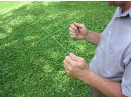
The dowsing frames will react by connecting the ends to each other in the place where the aquifers pass on the site
It is believed that the best time to search for water by dowsing is summer or early autumn. The most favorable periods:
- from 5 to 6 am;
- from 16 to 17 days;
- from 20 to 21 pm;
- from 24:00 to 1:00 am.
L-shaped frames are convenient to use in the field, but in the absence of wind. To work with the tool you need experience and skill. After all, the deviation of the frame can even depend on the emotional state of the operator.
For the same reason, before working with frames, it is better to refrain from drinking alcoholic beverages.Before you start searching, you need to learn how to work with a biolocator and “hear” it. Thanks to this, in the process of searching for water for a well, the operator will not be distracted even by the presence of closed water pipes on the site.
But it is worth noting that folk methods cannot give a 100% guarantee of obtaining the expected result. After all, even with a successful outcome, there is always a risk of obtaining with low productivity.
Methods for determining the depth of a reservoir from the shore
The correct measurement of depth and the choice of distance become the key to successful fishing. In a promising point, you can throw bait, and then equipment with bait. And if it is very easy to find interesting depth drops from a boat, then it can be difficult to do it from the shore. A depth gauge and one of the measurement methods can come to the rescue. The choice of method depends on the style of fishing.
- For a long time, fish have been caught with a fly rod. The fishing distance was limited by the coastline. It was possible to determine the nature of the bottom by shifting the sinker. If the float is on the surface of the water, then the weight is at the bottom. As soon as the displacement of the sinker causes the float to take up its working position, then the depth is set correctly. In such a simple way, you can measure the coastal area and find an interesting place for fishing.
- But spinningists know how to determine the depth at a long distance. During the step-by-step wiring, the bait sinks to the bottom, the moment of contact is transferred to the tip of the rod or given to the hand. Having calculated the time of the fall of the equipment, you can approximately determine where the deeper sections are, find the exits from the pits.
Today, anglers have many ways to accurately study bottom topography. After that, you can choose a suitable fishing distance and adjust the tackle to the selected place.
Optimal well depth for drinking water
A person who has nothing to do with drilling thinks something like this: water starts from 10 meters and the deeper it becomes, the cleaner and cleaner it becomes, and starting from 40 meters (conditionally), it is as clean as possible. It is this water that is potable, and a well for such water is called artesian. This is where the classic question arises: “at what depth is drinking water?” Having learned such a depth from someone, people want to drill a fixed well of 70 meters, or 30 or 100 meters.
We also often hear similar words: “I don’t need a lot of water, I just water the plot.” Some people believe that if a well is drilled in a summer cottage and the water will go mainly for irrigation, then it is possible to drill shallow. This is a myth and let's find out why it's not true.
About the beneficial qualities of artesian water
Water is recognized as the highest quality. This thick layer is located at a depth of 100 m. At the same time, artesian wells with a depth of more than 300 m are known. Special equipment is used to drill artesian wells. The water in them is distinguished not only by exceptional purity and high taste properties, but also, often, by the content of useful mineral salts.
However, regardless of the depth of the well, and the aquifer used, before using water for household needs or cooking, it is necessary to conduct a laboratory study to exclude the content of pathogenic bacteria and harmful impurities in it.
Preparation for the creation of an autonomous water supply system for a country house or cottage includes a number of stages. One of them is the definition of the layer from which water will be withdrawn. It is necessary to take into account a number of factors and conduct geodetic reconnaissance. An important parameter is the depth of drilling a well for water. It is determined based on the conditions in a particular area.
Verkhovodka
The aquifer closest to the earth. It lies at a depth of no more than 4-5 m. It is formed from sedimentary and melt water. Refers to unstable sources. May disappear in case of severe drought or frost with freezing of the soil by several meters.
The water in this layer is of low quality and contains a lot of impurities, bacteria, and contaminants that have penetrated from the surface into the soil. It is one of the suppliers of water for deeper levels and is suitable for a shallow well if there are no other sources for irrigation.
ground water
Usually located at a level of about 10 m, on the first water-resistant layer. They are formed during the infiltration of atmospheric precipitation and water from various water bodies - rivers, lakes, ponds.
This layer is suitable for wells and boreholes, but is characterized by unstable water quality. One of the sources of filling is the surface of the earth, but not all contaminants are filtered out when they penetrate the soil.
Water can change color if there is a swamp or peat bog nearby, and have an unpleasant odor. However, often the water in this layer is clean, suitable for drinking and cooking.
Interstratal waters
The third level of groundwater. It is located at a depth of 10-100 m between two waterproof layers of soil. This layer is stable
An important advantage is the purity of the water, and the deeper the level, the cleaner the source.
In the process of moving through different layers of soil, the water is repeatedly filtered, impurities and most bacteria disappear from it. Ideal for high production wells with a lifespan of up to 50 years. Most often, the depth of hydraulic structures does not exceed 50 m.
artesian waters
They lie at a depth of more than 100 m. There are frequent cases when water is extracted from artesian sources at a level of 250-350 m. These are the so-called limestone wells. They are distinguished by high power and high quality of water, often containing useful minerals and trace elements in a small concentration.
Mostly sources of this type are used for industrial purposes. However, with a moderate layer thickness and a relatively shallow depth, they are quite suitable for domestic purposes. When drilling a hydraulic structure of this type, special equipment is used.
Sectional soil: an example of the location of aquifers and hydraulic structures
How to check the depth of the well after drilling, so as not to be deceived
And in the end, let's move on to the most important point, how to verify the words of the drillers and find out how many meters they actually drilled. After all, it is generally accepted that a priori they want to deceive you.
After the drilling has been completed, the drilling crew hands over the well to you and makes a depth measurement
You must be present at this process, because it is you who sign the act of work performed and if something is wrong, then there will be no one to present claims.
Measurements are made by drillers with their drilling tools, namely drill rods, which have the same length (pictured). The bars are alternately lowered to the bottom, a mark is made on the last bar, then they are taken out and laid out. Then take a tape measure and measure the length of the rod and multiply by their number + part of the latter. Everything is simple. You have the right to measure at least every barbell.
As you can see in the photo, the rod is rigid metal and even if you want, it is impossible to lower more than necessary into their well. This is the simplest and most accurate method of measuring the depth of the well.
Therefore, when a well is handed over, come and check the depth so as not to do what we will write about later.
Practice shows that many do not trust this or were not there when the well was commissioned and are simply sure that they were deceived. Therefore, having received a working well, they begin experiments, sometimes right on the day the drillers leave.
-
Classic case #1.
After reading articles on depth measurement (from theorists), you decide to lower a hammer, ax or other heavy element into the well.Everything would be fine, but those who advise this method probably forgot that, at a certain depth (indicated in the passport), the well has a transition to a smaller diameter. Your hammer will rest against this smaller diameter and will not go further, you will decide that this is the bottom and consider that you have been deceived. -
Classic case #2.
Your hammer nevertheless entered this smaller diameter, plunges deeper and deeper into the water, the rope becomes heavy, and even if your object has sunk to the bottom, the rope itself stretches further under its own weight.
And it's good if you can pull your hammer back. It often happens that either the rope just breaks, or the hammer gets caught on something, you pull it and get a rope break, or you just can’t get your hammer back.
As a result, you lose the warranty, lose the opportunity to install the pump and get a new well that needs to be repaired. They will try to repair it for you, but for some money.
Sometimes the depth measurement service is provided by third-party workers whom you have called to install the pump. Their method is about the same - a load on a rope. The result is the same as with self-measurement.
You can learn more about cheating by drilling firms.
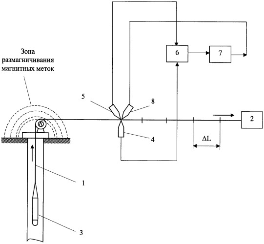
Acoustic Depth Gauge Application
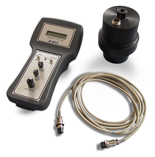
This device allows you to get the most accurate data on the depth of any structure. The device is most often used in the mining industry. The only drawback is the high cost of the device.
The resulting distance is proportional to the time interval between the input and output signals. After measuring the depth, this indicator is entered in the well passport. Knowing the methods of measurement, each of its owners will be able to check the parameter on their own.
Owners of country houses do not have the ability to connect to a centralized water supply system, which means they are forced to look for alternative solutions to the issue of water supply. The most popular ways to supply the household with water are to dig a well on the site or drill a well. Wells are most widely used due to certain circumstances and advantages. However, the price issue always remains relevant. How much will a well cost if its cost directly depends on the depth of drilling? And what is the quality of the water in it?