Plants
 Plants will prompt
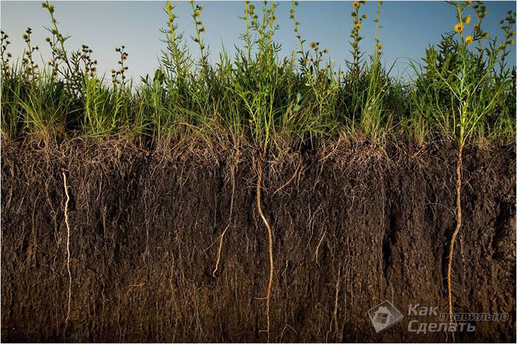
Plants serve as a good natural indicator of the depth of the top layer of groundwater.
In order to use this method, it is important that the site has been fallow for some time. This period will enable vegetation to find its niche.
You should pay attention to:
- Reeds. If it is on the territory allocated for development, then, most likely, the reservoir is located at a depth of 1 to 3 m.
- Cattail. It is a tall marsh grass. Often used for weaving various utensils. This view indicates that the liquid is about 1 m.
- Wormwood is a representative of Compositae. If it grows rapidly, then the limits of the aquifer are from 3 to 5 m. Construction can be freely carried out on such a site.
- Licorice is able to start up the root system to a depth of 5 m. Usually it indicates that the upper water threshold can reach 1.5 meters.
- Blackberries, raspberries - top water can reach 60 cm in a particular area.
- Gooseberries, currants and sea buckthorn are indicators of perched water at a level of 1 m from the surface.
- If apple and pear trees have been growing on the site for more than a year, then you can be calm: the water is at a level of 2 or more meters. The fact is that otherwise such trees do not withstand a longer stay with a lower occurrence of the water layer. With the growth of the root system, there is a greater consumption of oxygen, which is not enough, and the plant simply withers.
- For cherries and plums, water at a level of more than 1.5 meters will be required.
In the case where the site was cleared before the purchase, then you can ask around with the old-timers regarding the vegetation and their experience in construction work.
Deep artesian water-bearing layers
Having an artesian well in the country is the dream of any owner. It should be noted that the dream is difficult to fulfill. In accordance with the requirements of the subsoil law, such water intake is subject to mandatory licensing, and the sanitary protection zone of the well is at least 30 meters from it in any direction.
Thus, the exclusion zone will be about 40 acres, and any type of economic activity is prohibited on this territory. Will this land be sold to you - a big question and how much will it cost? Although there are many places in Russia.
A choice is possible when solving the problem - to drill a collective artesian water intake for a small village, then the costs will not seem excessive.
The depth of the well for water in this case can vary from 70 to 200 meters, drilling into such horizons is quite a common practice. The quality of life-giving moisture from such wells, as a rule, turns out to be very high, it is transparent and tasty, which is not surprising with such a thickness of the filter layer. Information about the significance and quality of water in the reservoir can be provided by a hydrogeological map of the area.
Separately, it is worth mentioning the gravel aquifer.
Drilling in such an environment is very difficult, the most productive process is flushing. But if clay mixtures are used, the clogging of the well is very significant and will require a long buildup, even if the water is backed up by internal pressure in the reservoir. Qualitatively opened layer gives a good debit and tasty water.
How deep to dig the foundation
Armed with these figures and the results of the study of the site, you need to select several options for foundations. The most popular are tape and columnar or pile. Most experts agree that with the normal bearing capacity of the soil, their sole should be 15-20 cm below the freezing depth. How to calculate it, we told above.
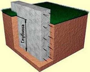
The foundation depth is the level to which the foundation needs to be deepened.
In doing so, keep the following recommendations in mind:
- The sole should rest on the ground with good bearing capacity.
- The foundation must sink into the bearing layer by at least 10-15 cm.
- It is desirable that groundwater is located lower. Otherwise, it is necessary to take measures to divert water or lower its level, and this requires very large funds.
- If the bearing soil is too deep, it is worth considering the option of a pile foundation.
Having chosen several types of foundation, having determined the depth of laying for them, an approximate calculation of the cost of each is carried out. Choose the one that is more economical.
Also note that to reduce the depth of the foundation, you can use an insulated blind area. During the construction of a shallow strip foundation, a blind area is required.
What is an aquifer map
Hydrogeological study of soils allows you to determine the types and characteristics of soil layers in a small area or a large area, as well as the level of groundwater. Based on the study and analysis of the results, a number of documents are compiled. As a rule, the local archives of settlements have long had geological sections and maps of aquifers. But outside the city or on newly developed sites, it is required to excavate soil samples and determine the location of the underground levels of water mirrors.
Underground, water behaves somewhat differently than in a tank, where there is no doubt about the horizontal level of its level. In the thickness of the soil, the line of the water mirror can bend under the influence of many factors:
- terrain;
- shape and placement of water-resistant layers;
- make-up and reset options;
- carrying capacity and density of soil layers;
- proximity to water bodies, etc.

When compiling maps, GWL measurements are used in available natural and artificial sources. These can be wells and workings, wells and pits, water bodies and water metering posts. For the "purity" of the data obtained, measurements at points located close to each other are performed on the same day due to the fact that the level of groundwater under the influence of external influences can change significantly. In this regard, maps of aquifers must be dated.
If, during the construction of the site, groundwater can be detected during the construction of a pit, then when performing a shaft well or an artesian well, specialists will need to look at a map of aquifers. Its absence in most cases leads to unforeseen situations. For example, in the process of lowering the well rings, it may turn out that the water is much deeper than the expected mark. The meaning in further work will disappear by itself, and the rings, most likely, will remain in the ground. In this case, it would be more profitable to immediately stop at the well device.
Experienced craftsmen recommend not neglecting familiarization with maps of aquifers or conducting reconnaissance drilling. By the way, it is possible to determine the proximity of the aquifer using folk methods, but this does not always lead to the discovery of drinking water.
Methods for determining the level of groundwater occurrence
By the height of plants, you can determine the depth of groundwater.
In the old days, the most common method was to install a clay pot well dried in the sun over the supposed place of water occurrence. It was turned upside down and after a while the inner surface was checked. If the inner walls fogged up, it was believed that groundwater was nearby.
At present, this method has been improved by the use of silica gel. This synthetic substance has the property of enhanced moisture absorption. Pre-granules are dried in an oven and poured into an unglazed clay container. Then a very accurate weighing of dishes with filler is carried out. If possible, it is better to do this on a pharmacy scale.The pot is wrapped in a dense dry cloth and buried at a depth of about half a meter in the place where it is planned to find out the depth of the aquifer. A day later, the vessel is removed and re-weighed. The difference in performance will mean the amount of liquid absorbed, and the larger it is, the closer the waters are located to the surface. The use of such a tool at several points at the same time will significantly reduce the time to search for groundwater.
Search for groundwater by natural features.
Fog in a certain place indicates a lower temperature of the earth's surface, which indicates the close location of underground water.
Observation of ancestors made it possible to systematize some natural phenomena to determine the occurrence of groundwater. The abundance of morning dew in a certain place indicates a lower temperature of the earth's surface, indicating the close location of a water vein. The accumulation of evening fog can serve as evidence of the same. Dogs do not like to lie in places close to water, but cats, on the contrary, settle in close proximity. The shallow depth of the aquifer attracts insects, midges and mosquitoes hover over it after sunset. But red ants and rats stay away from such places.
Moisture-loving plants are a good indicator of the proximity of groundwater. Even in the driest time, the vegetation will be juicy and green in the area where the depth of the water vein is insignificant. By the appearance of wild flowers and herbs, one can understand the approximate depth of water:
- cattail - 1 m;
- reeds - 1-3 m;
- black poplar - 0.5-3 m;
- wormwood - 3-7 m;
- alfalfa - up to 10-15 m.
Trees such as birch and alder indicate the shallow location of groundwater, while pine says the opposite - its roots go deep into the soil.
Joking aside, the dowsing method is still considered one of the most effective in finding water. Pieces of thick and not too flexible aluminum wire are used as frames. They are bent at a right angle so that about 10 cm remains for the handle. You can insert them into an empty ballpoint pen case, but it is believed that it is better to use elderberry, willow or viburnum sticks with the core removed. Slow movement along the area with the frames clamped in the hands continues until they begin to spin in the hollow handle. This will be the best point for the development of groundwater occurrence.
You can determine the depth of the water layer using the barometric method. It is advisable to use an aneroid barometer only if there is a natural body of water nearby. One division of the instrument scale corresponds to a height difference of 1 m. First, barometer readings are taken near a reservoir or well, and then at the site of the proposed drilling. The difference in readings is converted into meters and, adding to the depth of the first object, the desired result is obtained.
A reliable way to determine the depth of the water layer.
Test drilling has been and remains the most reliable method. Only self-reconnaissance gives a 100% result and does not lead to situations where the waters are at a much greater depth than expected, or a huge stone appears in the path of the drill, which is simply impossible to bypass.
The classic scheme of manual drilling of a well.
For greater efficiency in work, additional cutting blades are welded to its edges. In general, for exploratory drilling it is necessary to prepare:
- Boer;
- hollow pipes with a drill diameter for lengthening;
- shovel;
- earth haul truck.
This method is suitable for relatively soft ground. The drill crashes into the ground to a possible depth and is pulled up along with the soil, which is immediately poured into the wheelbarrow. In the process of working in the hole, you need to gradually add water to make the soil softer.If necessary, the extension tool is connected to the pipes using a spigot or threaded connection.
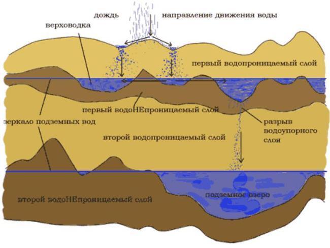
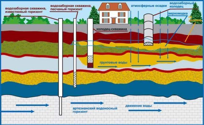
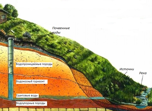
Aquifers and their occurrence
The rock structure is very heterogeneous. Even in one area at a distance of a meter, the "pie" - the composition of the layers and their sizes - can differ significantly. That is why it is so difficult to find water on the site, you have to drill several wells to find a normal aquifer. There are three main aquifers:
- Verkhovodka. The depth of occurrence of such waters is up to 10 meters. There is a top water, as a rule, under the first water-resistant layer - clay. In some areas, the top water is already at a depth of 1-1.5 meters, which does not please the owners of such sites - there are many difficulties. Verkhovodka - water, to put it mildly, is not of very high quality - it contains dissolved chemicals from the fields, and other pollutants. It can be used for irrigation, and in order to bring it to a state of drinking, a multi-stage purification system is required.
In each region and even in each area, aquifers are located differently.
I must say that it is not difficult to find a perch on the site. Knowing some features of the vegetation, having checked some points, you will determine the location of the water carrier with a fairly high accuracy.
With an aquiferous sandy layer, everything is much more complicated - the depths are serious, you have to focus mainly on the location of the wells near the neighbors, and not some indirect signs.
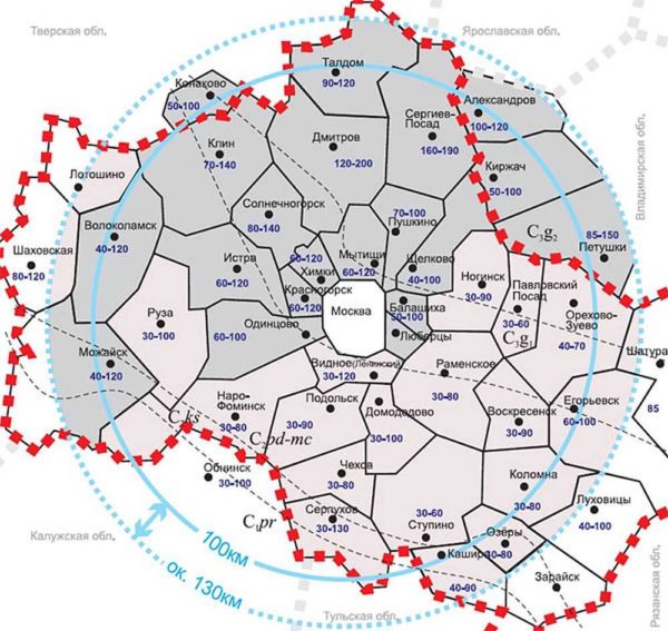
Depths of perched water in the Moscow region
You can find artesian water on the site only with the help of test drilling. Maps of the occurrence of aquifers can help. Since 2011 in Russia they are in the public domain (without payment). To get a map of your region, you need to send an application to ROSGEOLFOND. You can do this on their official website, or you can download the forms of the required documents, fill them out and send them by mail (with acknowledgment of receipt).
Varieties of cards
The name of these documents may be different depending on the nature of the data printed on them:
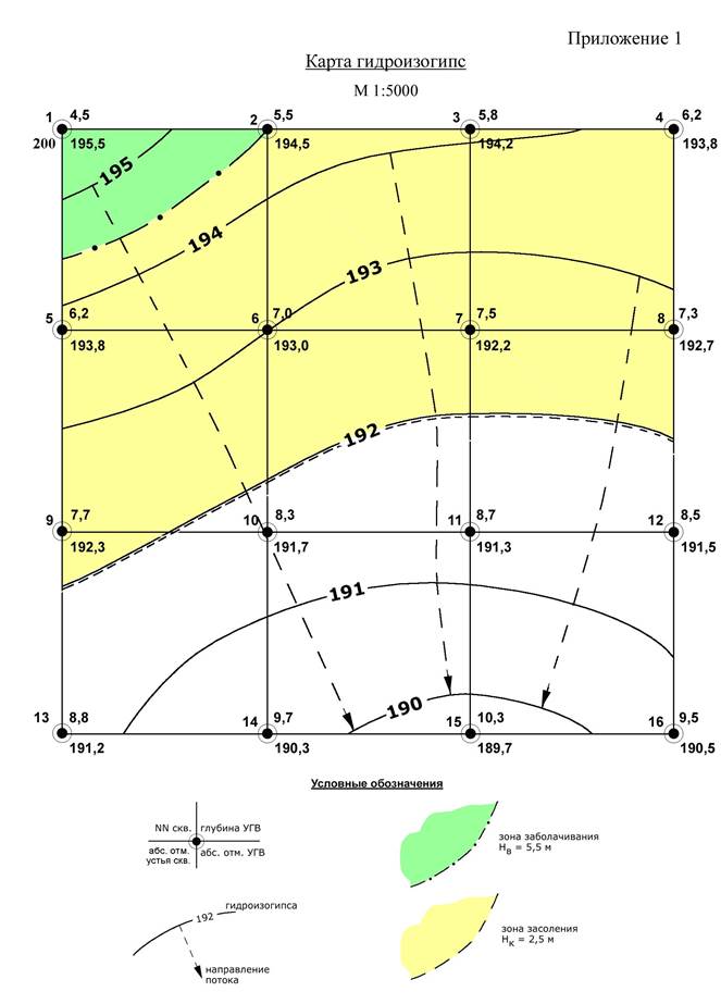 Fig.1. Hydroisohypses - the direction of the flow of water is perpendicular to the lines
- hydroisohypses - lines connecting points in the bowels of the earth, with the same level of the groundwater table relative to the zero mark. It is displayed on the maps as a wavy line formed when connecting points explored during geological research. Hydroisohypses are compiled for free-flowing water-bearing layers and give a general idea of the movement of groundwater. Given the location of the lines on such a map, it is possible to determine the characteristic direction and slopes of fluid flows, the places where the reservoirs are fed and the points of their discharge, as well as the nature of the relationship between groundwater and open water bodies - whether they are feeding or draining;
- hydroisopieses - lines on the map of water resources, obtained by connecting points with the same pressure of groundwater;
 Fig.2. An example of mapping hydroisopieses
maps of groundwater level differences are the most informative in relation to determining the possibility of drilling a well on a site in the surveyed area. Solid lines connect exploited objects with the same level of occurrence of aquifers;
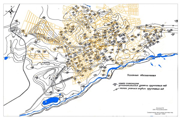 Fig.3. Map of groundwater level differences
graphs of fluctuations of the water column in wells.
According to the graph in Fig. 4, it is obvious that the water intake is intensively filled in spring during snowmelt and in autumn with heavy precipitation (data for 2004), the low level in 2005 is explained by a dry autumn with little precipitation. Recall that the well level is determined by the distance from its mouth to a stable water surface in the absence of pumping.
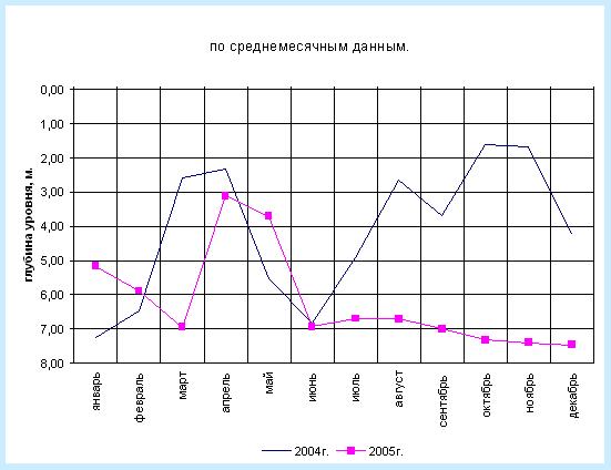 Fig.4. Graph of seasonal fluctuations in the water level in the well
schemes of hydrogeological sections - give a clear idea of the presence and location of water horizons in the area under study.The map allows you to know the location of the wells to get a clear picture of the expected depth of drilling. Combining the obtained data with a map of groundwater level differences, you can get all the necessary information about the nature of the future shaft, the drilling method and the necessary materials.
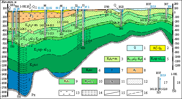 Fig.5. Schematic hydrogeological section of the area according to operating wells
All the mentioned documentation is compiled on the basis of an analysis of existing water intakes. The piezometric surface index depends on the in-situ water pressure and horizon height. Conventionally, the level can be both above the surface of the earth and in it. In fact, the indicator indicates the height of the rise of water when opening an artesian well. It can be used to preliminarily understand the length of the casing, knowing that it should be above the piezometric level.
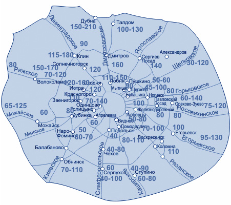 Fig.6. Map of well depths in the Moscow region
Kirill Kazakov, who lives in the Chekhov district of the Moscow region, is interested in
If there was a desire to acquire an individual water source, then how to determine the aquifer when drilling a well?
Expert answer:
The underground layer of pure natural water is a reservoir located between impermeable layers of limestone or clay. To gain access to it, you need to have the ability to correctly determine its location before drilling a well. There are some of the simplest and most common ways.
The study of the terrain - the most sure signs of the presence of an underground reservoir are depressions and lowlands. Hills and hills, on the contrary, reduce the chances of quickly reaching the goal.
Some plants may indicate the depth of the aquifer:
- reeds and cattails grow in places where groundwater does not fall below 3 meters;
- black poplar indicates the location of the water carrier on the horizon of 4–5 meters;
- wormwood and alfalfa - about the need for deepening up to 15 meters.
The size of the sand extracted during the drilling process is also important in identifying the water content of the soil:
- coarse sand reports significant removal;
- small - about approaching the desired channel.
 Scheme of distribution of different aquifers
In addition to the above methods, it is possible to assume the depth of the underground source by studying the root system of trees growing on the site. Weak root development is a sign of the proximity of water. If the roots stretch into long rods, this is evidence of the deep location of the water carrier.
The simplest and most effective way to correctly choose the location of a natural reservoir with liquid is to contact specialized organizations involved in drilling wells for water.
Such enterprises have extensive experience, and also have at their disposal hydrogeological maps of the serviced area indicating the places of occurrence and features of the formation of groundwater. This will allow you to accurately solve the problem of how to determine the aquifer when drilling wells and find the best option for arranging a source in a particular area. This will save time and get professional help in securing access to natural water resources.
Video: How to find an aquifer
A selection of questions
- Mikhail, Lipetsk — What discs for metal cutting should be used?
- Ivan, Moscow — What is the GOST of metal-rolled sheet steel?
- Maksim, Tver — What are the best racks for storing rolled metal products?
- Vladimir, Novosibirsk — What does ultrasonic processing of metals mean without the use of abrasive substances?
- Valery, Moscow — How to forge a knife from a bearing with your own hands?
- Stanislav, Voronezh — What equipment is used for the production of galvanized steel air ducts?
How can you find out the depth of water
Residents of apartment buildings who do not have summer cottages know that water can be obtained by simply opening a tap, and only problems in the work of the city water canal can disrupt the usual procedure for washing dishes or taking a shower. They do not suspect what problems those who are forced to provide water supply to their homes on their own face.
Location of groundwater.
In the absence of water for irrigation and household needs, as well as the remoteness of water supply networks, the only way out is to build a well or drill an artesian well. This time-consuming process begins with knowing the depth of the aquifer. Often, professionals are hired for this purpose, but you can do without the cost of their services and find the point at which groundwater is located on your own. For this, not too complicated methods and means that are quite accessible to each person are used.
How to find water with a frame
Very often, the search for water for a well is carried out using dowsing, an old and very accurate method for determining the watercourse. Before starting the search, you will need to prepare frames, which are pieces of aluminum wire about 40 cm long. Their ends at a level of about 10 cm are bent at a right angle. It is believed that it is best to insert frames into tubes of elderberry that have been cored. The wire in the tubes must turn absolutely calmly. Also, forks of branches of viburnum, willow or hazel can be used as a frame.
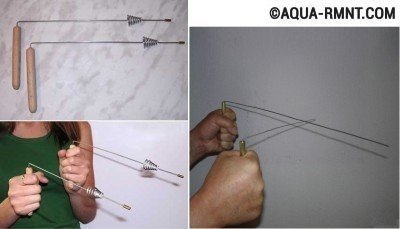
Frames are small pieces of aluminum wire bent at right angles.
Next, the following steps are performed:
- We determine the position of the cardinal points using the compass and mark them on the territory of the site with pegs.
- We take a frame in each hand. We press the elbows to the sides, we direct the forearms parallel to the ground, so that the frame becomes, as it were, an extension of the arms.
- Slowly we cross the territory of the site from north to south, and then from east to west. In a place where there is a watercourse underground, the frames will begin to move and intersect. This place is marked with a peg.
- Considering that water usually lies in the form of peculiar veins, having found one point, we determine the entire watercourse. To do this, we perform the previous operation several times, each time marking with a peg the place where the frames intersected.
We determine the power and depth of the watercourse. We imagine that we are diving to the depth of our own growth, then to two, three or more such distances. The first time the frame will react to the upper border of the water vein, the second - to the bottom.
A well on the site is a practical solution for providing water supply to the house and personal plot. Methods for self-search of an underground watercourse will determine the presence of water on the site and help make a decision on the possibility of arranging the system. But do not rely too much on them, because all these methods, although considered quite accurate, give only general answers to questions. Only specialists will be able to determine the presence of an aquifer, its depth and thickness absolutely accurately.
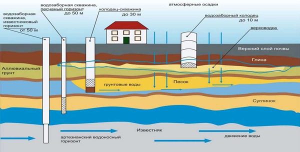
Aquifer

The quality of water is highly dependent on aquifers of various depths. Therefore, the service life of a well or well and the quality of drinking water depend on the correct choice of the location of the future water source. Groundwater is divided into perched water, groundwater and interstratal water.
Verkhovka is used as an additional source of water for watering the garden. But even such use is not always justified, so when oversaturated with chemicals, the opposite effect can be observed - the garden will not give the expected harvest.
ground water
The main source of water that a person can use is groundwater, which occurs at a depth of up to 10 m. The depth of groundwater depends largely on the relief.Therefore, in the same area there may be different levels of occurrence.
Hence the answer to the question: Why does a neighbor have 5 rings 100 meters from me, and I need to make 7. Groundwater is considered a permanent aquifer, but it strongly depends on the regularity of precipitation. And in dry weather, water can “leave”. Water from such a layer must be subjected to additional purification for its subsequent use as drinking water.
To understand why this happens, it is necessary to follow the process of water purification.
So, during precipitation, moisture seeps through permeable rock, encountering almost no resistance on its way, so the degree of its purification is very small.
This forms a layer called "Ground Water".
Since the layers lie unevenly, and in some places their difference is very significant, springs may appear. The higher the spring is located, the higher the likelihood that groundwater has broken through.
- We will carry out the installation of electrical equipment and automation systems for wells and wells
- We will install all pipelines and water supply to the house
- We will make a calculation of the water treatment system, install and configure.
- We will conduct free consultations on the choice of pumps, water purification and softening systems
See prices for wells
Expert Tip: In some areas, the water from this layer is so polluted that high-quality cleaning at home is simply impossible. Therefore, only testing the water in the laboratory will help determine the contamination of the aquifer, and, if necessary, select the best option for the filter system.
Cleaner water is located in the interstratal layer, the depth of which is from 10 to 100 m.
The peculiarity of the layer is that from here we get water ready for drinking without additional purification, because. the layer is protected on both sides with waterproof layers. Interstratal waters accumulate slowly, as they are located at a greater depth, and therefore are cleaned more efficiently.
This is facilitated not only by a large layer, but also by the high density of the soil. The water-resistant layer not only reliably separates interstratal water from groundwater, but part of the moisture still seeps through it, while being effectively cleaned. The bulk of the water enters the interstratal space in those places where the reservoir comes to the surface.
The farther from this place the water is taken, the cleaner it is.
The source of springs located in the lowlands is most often interstratal waters. Often, interstratal waters are saturated with minerals that will benefit a person only if they are moderately consumed in the body. Water saturated with minerals cannot be constantly drunk and cooked from it.
Comparative analysis of interstratal and groundwater
Thanks to the comparison table, you can more clearly see the difference between groundwater and interstratal water.
|
Factor |
ground water |
Interstratal waters |
|
Depth |
Less than 10 m |
10 to 100 m |
|
Usage |
As process water |
As drinking water |
|
Water level |
Depends on precipitation |
Does not depend on precipitation, except in cases where there is no upper water-resistant layer |
|
Can it go out under pressure |
Not |
Yes |
If you want to install a well in the Solnechnogorsk region or a well in Solnechnogorsk, then you need to look for interstratal water.
Our company has an impressive experience in the arrangement of wells and wells, which has been accumulated in the course of more than 15 years of practical activity.
You can clarify your questions and agree on cooperation by calling +8 (499) 755-64-44.
Effective ways to find water
There are more than a dozen ways to determine the proximity of water to the surface. The search for water under the well can be done using one of the following effective methods.
Using silica gel
To do this, the granules of the substance are carefully dried beforehand in the sun or in the oven and put into an unglazed clay pot. To determine the amount of moisture absorbed by the granules, the pot must be weighed before instillation. A pot of silica gel, wrapped in a non-woven material or dense fabric, is buried in the ground to a depth of about a meter at the site where the well is planned to be drilled. A day later, the pot with the contents can be dug up and weighed again: the heavier it is, the more moisture it has absorbed, which in turn indicates the presence of an aquifer nearby.

The use of silica gel, which belongs to the category of substances that have the ability to absorb moisture and retain it, will allow in just a couple of days to determine the most suitable place for drilling a well or arranging a well
In order to narrow down the search for water for a well, several of these clay containers can be used simultaneously. You can more accurately determine the optimal location for drilling by re-burying the silica gel pot.
barometric method
A reading of 0.1 mm Hg of a barometer corresponds to a difference in pressure height of 1 meter. To work with the device, you must first measure its pressure readings on the shore of a nearby reservoir, and then move together with the device to the place of the proposed arrangement of the source of water production. At the well drilling site, air pressure measurements are taken again, and the water depth is calculated.
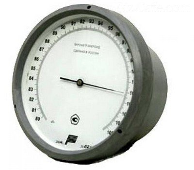
The presence and depth of groundwater is also successfully determined using a conventional aneroid barometer.
For example: the barometer reading on the river bank is 545.5 mm, and on the site - 545.1 mm. The level of groundwater occurrence is calculated according to the principle: 545.5-545.1 \u003d 0.4 mm, i.e. the depth of the well will be at least 4 meters.
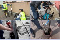
Exploration drilling
Trial exploration drilling is one of the most reliable ways to find water for a well.
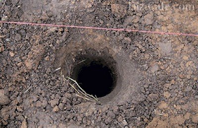
Exploratory drilling allows not only to indicate the presence and level of occurrence of water, but also to determine the characteristics of the soil layers occurring before and after the aquifer
Drilling is carried out using a conventional garden hand drill. Since the depth of an exploration well is on average 6-10 meters, it is necessary to provide for the possibility of increasing the length of its handle. To carry out the work, it is enough to use a drill with a screw diameter of 30 cm. As the drill deepens, so as not to break the tool, excavation must be carried out every 10-15 cm of the soil layer. Wet silvery sand can be observed already at a depth of about 2-3 meters.
The place for arranging the well should be located no closer than 25-30 meters from drainage trenches, compost and garbage heaps, as well as other sources of pollution. The most successful placement of the well is on an elevated site.
Terrain-following aquifers at elevated locations provide cleaner, filtered water
Rain water and melt water always flows from the hill to the valley, where it gradually drains into the water-resistant layer, which in turn displaces clean filtered water to the level of the aquifer.
Conclusion and popular video on the topic
Anyone who wants to drill a well should read about how to find out how deep the water is. This can be done in several ways:
- Using earthenware, silica gel, shards, etc.
- By determining the places of accumulation of plants of the same species.
- Observing natural phenomena on the territory of the site.
- Applying the principle of dowsing.
Some methods indicate more accurately, but are not applicable if the external manifestations on the site do not differ from the place. The terrain may be flat, plants evenly distributed, etc.In this case, you can try using frames or a pendulum. But in order to determine exactly, it is better to involve specialists in the process who will conduct geological exploration.