Folk methods
Even in ancient times, people learned to determine where a water source could be, observing nature and using elementary physical laws. The following popular methods can be noted:
- Observation of the formation of fog. In a fairly warm season, in the morning and evening, a foggy cloud forms in the places closest to groundwater. The density of such a cloud indicates the depth of the aquifer. It is necessary to constantly monitor such phenomena in the summer cottage and try to draw up an approximate map.
- Animal observation. Some animals are able to tell a person where to look for water. You just need to carefully observe their behavior. So, field mice will never dig holes with a close location of groundwater. Horses and dogs can be good helpers. In extreme heat, horses begin to beat with their hooves, and dogs dig the ground in the places closest to the source. Poultry is also able to feel the proximity of water: chickens will not rush in the area where the reservoir comes close, while geese, on the contrary, try to nest closer to the water source.
- Plant observation. Photo 2 shows some plant "indicators". Moisture-loving vegetation does not grow where the land is too dry due to the deep location of the aquifer. In those areas where coltsfoot, hemlock, sorrel, nettle grow wildly green, you can plan a place for a well. In principle, even the approximate depth to the water carrier can be determined by plants. Willow, alder, birch indicate a shallow depth, and the slope of their crown indicates the location of the right place. Cherries and apple trees do not like dampness, and therefore prefer areas with a deepened layer. When groundwater approaches close to the surface, their root system begins to rot (see photo 2. Illustration of plant observation).
Dowsing Principle
This section shows a method that has also been used for a very long time, however, it causes controversy among specialists, and its effectiveness is questionable. However, a sensitive person is able to find water deposits in this way.
In principle, such a technology should work, but there are a lot of interferences on the site that reduce performance (reservoirs, streams, puddles, geological disturbances in the ground, utilities, pieces of metal, etc.). It should be noted that in areas where there are no random water volumes, dowsing efficiency is estimated at up to 75%.
The search is carried out as follows. For research, you can use an aluminum frame or vine. In the first case, 2 pieces of aluminum wire 35-45 cm long are bent at an angle of 90º, and the bent end is 12-16 cm. The wire is inserted into the tubes in the form of a reed so that it can turn freely.
A person takes the tubes with wire in both hands, directing the bent ends in different directions, and begins to move around the site. When passing over an underground stream, the wire frames will turn inward. The place where such a phenomenon occurred is noted. Then, for verification, a movement is carried out perpendicular to the first direction. If everything repeats in the same place, then this is the right point for digging a well.
The second method involves the use of vines. A branch is cut off, which has 2 branches, between which the angle is about 145-155º, and dries well. When searching for water, the ends of the vine are taken in different hands so that the branches are in the center and point upwards. When passing over the source, the vine will turn.
professional methods
It is possible to absolutely accurately calculate the aquifer during an engineering geological study. Such experiments cannot be carried out independently. To do this, you must have special knowledge and skills, as well as have the necessary equipment.
Services for studying the hydrogeological conditions of the area, determining the quantitative and qualitative assessment of the water reserve are provided by specialized companies, one of the activities of which is engineering geology.
A promising method for finding the optimal location for drilling wells is hydrogeological survey. It is she who allows:
- discover aquifers;
- establish groundwater reserves.

Based on the results obtained, conclusions are drawn regarding the feasibility of drilling a well in the specified area.
There are other professional methods of exploration, which include:
- electrical sounding;
- seismic exploration;
- exploration drilling.
The only drawback of such methods of finding the best site for a well is the need to incur financial costs aimed at paying for the services provided by specialists.
For many, this circumstance is decisive in order to refuse to use such effective methods.
Where not to look for water
The vegetation growing on the site, as well as its relief features, make it possible to determine not only the proximity of water, but also its absence. Water should not be sought in the following places:
- in hilly areas;
- near bodies of water, including rivers, lakes and ponds;
- in the immediate vicinity of the cliffs of the rivers;
- in the area where beech or acacia grows;
- in close proximity to quarries or water intakes.

No living creature can survive without water. This means that the aquifer is like a golden vein, and it is no less exciting to look for it. Own well allows you to solve the problem of lack of central water supply on the site. But even in the absence of this problem, autonomous water supply will significantly save time and money. The main thing is that when starting to search for water, use not one method, but several.
Currently, the most popular way is to use aluminum wire. However, even after finding the place of water occurrence, it is necessary to use other methods that will confirm this fact and avoid mistakes.
Deep artesian water-bearing layers
Having an artesian well in the country is the dream of any owner. It should be noted that the dream is difficult to fulfill. In accordance with the requirements of the subsoil law, such water intake is subject to mandatory licensing, and the sanitary protection zone of the well is at least 30 meters from it in any direction. Thus, the exclusion zone will be about 40 acres, and any type of economic activity is prohibited on this territory. Will this land be sold to you - a big question and how much will it cost? Although there are many places in Russia.
A choice is possible when solving the problem - to drill a collective artesian water intake for a small village, then the costs will not seem excessive.
The depth of the well for water in this case can vary from 70 to 200 meters, drilling into such horizons is quite a common practice. The quality of life-giving moisture from such wells, as a rule, turns out to be very high, it is transparent and tasty, which is not surprising with such a thickness of the filter layer. Information about the significance and quality of water in the reservoir can be provided by a hydrogeological map of the area.
Separately, it is worth mentioning the gravel aquifer. Drilling in such an environment is very difficult, the most productive process is flushing. But if clay mixtures are used, the clogging of the well is very significant and will require a long buildup, even if the water is backed up by internal pressure in the reservoir.Qualitatively opened layer gives a good debit and tasty water.
Popular ways to search for water on the site
If desired, the search for water under the well can be done in several ways. The most common of them:
Use of pottery
The ancient method of determining the presence of water involved the use of a clay pot. It was dried in the sun, then turned over and placed on the ground over the place where the water vein was supposed to lie. After a while, the dishes fogged up from the inside, if there really was water under it. Today, this method has been somewhat improved.
You need to take a liter or two of silica gel, which is an excellent desiccant. It is thoroughly dried in the oven and poured into a clay pot. After that, the dishes with the gel are weighed on accurate scales, better than pharmaceutical ones. Then they are wrapped in cloth and buried to a depth of about half a meter in the place where it is supposed to drill a well. Leave it there for a day, then dig it out and carefully weigh it again.
Not one or two aquifers have been found with silica gel yet
The more moisture absorbed into the gel, the closer the water. You can bury several pots at the initial stage and choose a place with the most intensive return of water. Instead of silica gel, an ordinary brick can be used, which is also dried and weighed.
Observations - where do plants grow?
Some plants are excellent indicators of underground water.
Plants will tell you if there is water in the area
For example, a birch growing above a stream will be of low height with a knotty, twisted trunk. The branches of the tree located above it will form the so-called "witch's panicles". The water close to the surface will show thickets of woodlice, a low herbaceous plant. River gravel directly points to the watercourse located under it. But the pine, with its long tap root, says the opposite - in this place the water is deep enough.
Definition by height difference
This method can only be used if there is any body of water or well nearby. You will need an ordinary aneroid barometer, with which pressure will be measured. Based on the fact that for every 13 m of elevation difference, the pressure will drop by about 1 mm of mercury, one can try to determine the depth of groundwater. To do this, you need to measure the pressure at the site of the proposed well and on the shore of the reservoir. The pressure drop is about half a mm Hg. Art. indicates that the depth of the aquifer is 6 or 7 meters.
Observations of natural phenomena
The soil, saturated with underground moisture, will surely evaporate it.
In the early morning or evening at the end of a very hot summer day, you should pay attention to the area where it is supposed to equip the well
If fog forms over it, there is water there. It is best if the fog rises in a column or swirls, which means that there is a lot of moisture and it is close enough. You should also be aware that waterproof layers usually follow the terrain. Thus, in the hollows and natural depressions, surrounded by hills, there will definitely be water. But on the slopes and plains it may not be.
Groundwater types
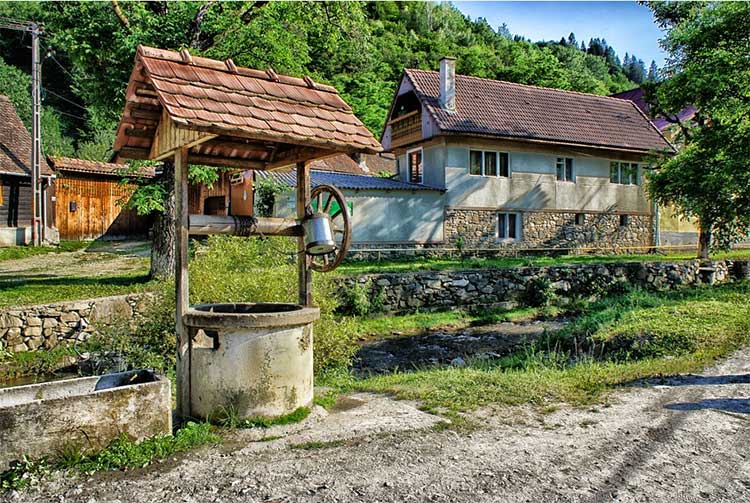
By building a well or building a well, the owners of suburban areas solve the problem of lack of drinking water.
 Groundwater is divided into three types
Before you start searching for water for a well, using folk methods and modern professional methods, you should determine and record the availability of such resources. You should find out how deep the aquifer is underground.
What are the types of groundwater?
- Verkhovodka. This type of groundwater occurs within 2-5 meters from the surface. It is formed as a result of the filtration of precipitation.This type of water can fluctuate because it is shallow: during the dry period it decreases, and after precipitation it rises.
- Ground water. They occur in sedimentary rocks at a depth of 8-40 meters from the surface. From above, they are protected by several layers of rocks, so the change of seasons does not affect them. Sometimes they independently make their way with springs in the depressions of the relief and supply clean tasty water.
- Artesian waters. They occur most often at a depth of more than 40 meters. Most often they are found in rocky limestone along cracks. There are no clay suspensions in the water, but there are mineral salts. The flow rate of artesian wells is quite stable.
Qualitative parameters and quantitative indicators of the aquifer are of key importance. Hydrogeologists most often use the preliminary exploration method when searching for and determining the depth of an aquifer.
Old-fashioned ways to find water for a well and a well
Wells have been built to extract water since ancient times, and even then there were many ways to find their correct location. They were based on observation of animal behavior and atmospheric phenomena, analysis of the surrounding landscape and various signs to determine where a water vein comes close to the ground, and where a well can be dug.
Based on many years of experience, it is known that a well should not be dug in areas with significant elevations in relief, on a steep bank of a river, near quarries and canyons. Near the swamp and the low bank of the river, the water will be undrinkable. In hollows and lowlands, the probability of finding a water vein is higher. Do-it-yourself search for water for a well in old-fashioned ways is quite often used at the present time.
Pleasant and useful to follow the fog
When looking for a place to build a well, it is nice and useful to follow the fog. This atmospheric phenomenon can also be observed in the warm season, early in the morning and in the evening.
It is necessary to pay attention to the place where its density is highest, just there the underground water layer comes closest to the soil surface.

If fog is concentrated and swirling in the same place in the morning, it can be said with certainty that there is water there. This is due to the fact that this kind of fog is formed by evaporation of underground moisture. Unlike ordinary fog, which is motionless, wet vapor swirls or spreads along the surface of the soil.
Interesting observations - how plants grow
It is very useful to observe how trees and shrubs grow in their summer cottage. Thickets of reeds appear in places where water occurs no deeper than three meters below the soil surface, wormwood grows above the aquifer, the distance to which varies from five to seven meters. Cowberry, bird cherry and wild rosemary are also located in humid places.
Willow and alder always grow near the exit of moisture to the surface of the earth. The search for water should begin where the crown of moisture-loving trees is tilted. But trees such as apple and cherry will never feel good in such places. In this case, they get sick and bear rotten fruits, therefore, if a newly planted apple tree begins to wither before our eyes, a well must be dug in this place.
Our smaller brothers will not tell, but they will show
Our smaller brothers do not know how to talk, but they can show by their behavior where the aquifer is located. Rodents will never equip their minks in places with high ground moisture. In hot weather, a thirsty horse begins to hoof where ground moisture is close.

Fleeing from the heat, a four-legged friend of man lies on the ground in a previously dug hole near the aquifer. Laying hens will never lay their eggs in wet places, but geese and ducks do just the opposite.Midges swarm and gather in columns where water is close.
1. The concept of groundwater regime
Underground mode
waters are regular in time
changes that are taking place in
aquifer as episodic,
daily, seasonal, annual, perennial
and secular fluctuations due to
meteorological and geological
processes. The concept of the mode of underground
water covers all aspects of their activities
and properties: temperature, physical
condition, nature of water exchange, level
(head), flow rate, chemical and gas
composition, etc. The groundwater regime can
be very fickle (top watering),
changeable, dependent on episodic
climatic factors (upper
groundwater horizons), constant
(lower groundwater horizons), very
permanent (artesian waters).
Impact on construction
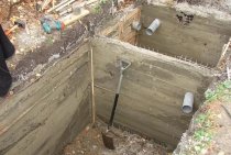
The design of any structure involving the pouring of the foundation should always begin with a measurement of the level of groundwater. The higher their location, the less the soil is able to withstand the bearing supports. If the occurrence of the underground aquifer is at a depth of less than 2 meters, then this is considered a high level of groundwater. With such an arrangement, construction that requires the construction of a pit or trench should be abandoned.

Scheme of a test well for determining the level of groundwater.
It is also worth avoiding construction if, at a high level of groundwater, there is sandy soil with a silt admixture between the earth's surface and the aquifer. The ingress of moisture into the layers of sandy rock will lead to a change in the soil (it will begin to “float”), which will adversely affect the ability of load-bearing structures to withstand the loads created by the building itself. If a layer of shale is located at this level, then the ingress of water into it will lead to its softening, due to which the stability of the soil will be lost, which will inevitably contribute to the curvature of the foundation level.
In any case, in the presence of such problems, the cost of development will be unreasonably high. The fact is that groundwater will constantly fill the dug pit, even if there is high-quality waterproofing and drainage, which will not allow the foundation to be poured. Such measures will only provide the necessary effect for a short time, but the groundwater itself will not disappear and, after a short period of time, will again restore its original level.
The level of the underground aquifer causes a limitation in the form of the choice of foundation, its depth, size and construction time. In addition to these indicators, the level of the underground aquifer imposes restrictions on the choice of building materials and their technical characteristics (density, strength, water tightness, etc.). The decision to equip basements and basements also directly depends on the level of groundwater.
Scheme of lowering groundwater.
Therefore, in construction, the norm of the distance from the base of the foundation to the underlying groundwater, equal to 0.5 meters and above, is adopted. This will make it possible to equip all load-bearing structures in accordance with the standards and guarantee the reliability of the operation of the constructed building. If the calculation was performed without taking into account this norm, then uneven heaving of the soil will occur, resulting in a distortion of the foundation, which will cause cracks in the structures, which can lead to their collapse. That is why the groundwater level must be determined at the design stage of the building.
Groundwater conditions
According to the conditions of occurrence, the following types of groundwater are usually distinguished:
Perch waters. Verkhovodka is called underground water, which lies at a shallow depth in the aeration zone - the zone of free air penetration.Usually, perched water does not have a continuous distribution, but forms relatively small lenses, which are underlain by water-resistant rocks (Fig. 23). The thickness of such lenses of perched water usually does not exceed 0.5-1 m, rarely reaches 2-3 m. Here the water is already in gravitational form and has a level. The water level of perch water is subject to significant fluctuations, which explains its disappearance in wells in areas with a dry climate.
Ground water. Atmospheric water, seeping from top to bottom to the aquiclude, and then moving in a horizontal direction, gradually fills all the voids of the rock. This is how aquifers arise (Fig. 23).
aquifer called a layer or layer of rock in which the pores, voids and cracks are filled with water. Each such layer has a roof and a sole. If the reservoir is not completely filled with water, then only its water-saturated part is understood as an aquifer. The first permanent aquifer from the earth's surface is called the groundwater horizon.. Groundwater has a free surface - mirror, or groundwater level. This level is not permanent. It usually rises during rainy periods and decreases during dry periods. If the level of groundwater in some area rises to the earth's surface, then a swamp is formed here.
In general, groundwater is characterized by the presence of a free water surface - the level, the presence of only one, underlying, aquiclude and the absence of pressure.
Interstratal (formation) waters. The difference between interlayer waters lies primarily in the fact that they are enclosed between two aquicludes, that is, they are limited by them both from above (from the side of the roof) and from below (from the side of the sole). Aquifers containing interstratal waters are usually characterized by a vast distribution area, often measured in thousands of square kilometers. At the same time, they lie at a considerable depth, coming to the surface only on the periphery.
Groundwater together with its host rocks form hydrodynamic systems, which are divided into non-pressure and pressure.
Non-pressure hydrodynamic systems are usually characteristic of groundwater basins that do not have a natural head.
Within pressure systems, atmospheric water enters the permeable formation in areas where it is exposed on the surface, in the so-called nutrition areas. Gradually, atmospheric moisture penetrates deep into and completely saturates the entire formation. Moving along the reservoir, water reaches other areas of its exit to the surface and self-spills, forming sources of groundwater. This unloading area, or drainage formation waters. Depending on the relief and the altitude position of the supply and discharge areas in the central, most sag part of the basin, there may be conditions favorable for creating pressure, i.e. spontaneous outpouring of water under pressure (Fig. 24, a).
Thus, in the central part of the basin, an area is formed head, within which water from wells is able to pour out in the form of a fountain. The height of water rise depends on the location of the wells relative to the areas of supply and drainage and on the hydrostatic level.
Hydrostatic (piezometric) level an imaginary surface is called, passing through the area of \u200b\u200bfeeding and unloading and determining the height of the rise of water in a given place (Fig. 24). The piezometric level is usually expressed in absolute elevations relative to sea level. Artesian water cannot rise above this level when spouting.
Another characteristic of the pressure area is hydrostatic (piezometric) head, which is understood as the height of the water column from the top of the aquifer to the piezometric level. The piezometric head is expressed in meters.
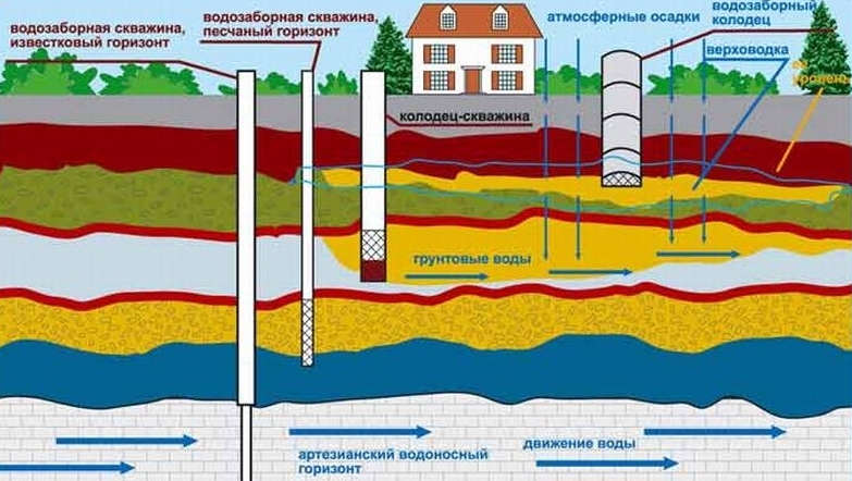
How deep does an aquifer live in the ground?
An aquifer in the ground is held in place by clay or rock boundaries that prevent moisture from rising to the surface or sinking down. Water-resistant layers are located, between which there is an aquifer, at various angles, and cavities filled with water are formed in the places of their bends. Such circumstances are the subject of research during the construction of the well. Having become acquainted with the following figure, we will more easily understand where you can dig a well.
When arranging the mine, you can find an aquifer located too close to the surface of the earth at a depth of less than two and a half meters. It is not suitable for building a well, as it is filled with atmospheric precipitation seeping through the soil in the form of rain, melted snow, and so on.
A lot of dirt accumulates in the formed underground lake, the water from it is not suitable for drinking. In addition, in the hot summer it can simply dry out, and there will be no water in such a well until the rainy season.  The layout of aquifers in the earth
An aquifer suitable for the construction of a well is located in the ground at a depth of about fifteen meters. When seeping into the ground, the water is cleaned of dirt, debris and harmful impurities in thick layers of sand and it can be used for cooking and drinking.
Methods for minimizing risks from groundwater
But even in cases where there is information about the non-aggressiveness of groundwater to concrete in a given area, the abolition of the waterproofing of the underground parts of the building is fraught with a good decrease in the service life of concrete structures. Too great an impact on nature, including groundwater and the degree of its aggression, technogenic factors. The possibility of close construction is one of the causes of soil movements and, as a result, changes in the behavior of groundwater. And chemistry and its "accumulation", in turn, is directly dependent on the proximity of agricultural land.

Accounting for the level of groundwater, as well as seasonal changes in this level, is archival for private construction. High groundwater is a limitation in choice. If not all, then a huge share of the economy of an individual builder depends on it. Without taking into account the behavior and height of groundwater, it is impossible to choose the type of foundation for the house, make decisions about the possibility of building a basement and basement, arrange cellars and a sewer septic tank. Paths, playgrounds and all site improvement, including landscaping, also require serious consideration of the impact of groundwater at the design stage. The matter is complicated by the fact that its behavior is closely related to the structure and types of soils on the site. Water and soils must be studied and considered as a complex.

Verkhovodka, as a type of groundwater, can create huge problems, and not always seasonal. If you have sandy soils, and the house is built on a high bank of the river, then you may not notice seasonal high water, the water will leave quickly. But if there is a lake or a river nearby, and the house stands on a low bank, then even if there is sand at the base of the site, you will be on the same level with the reservoir - like communicating vessels, and in this case the fight against perched water is unlikely to be successful, like any fight with nature.

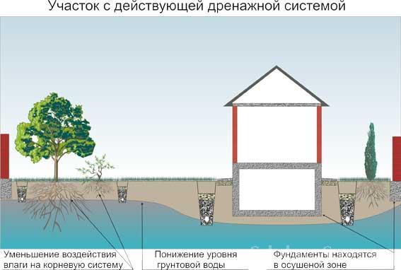
In the case when the soil is not sand, reservoirs and rivers are far away, but the groundwater is very high, your option is to create an effective drainage system. What will be your drainage - ring, wall, reservoir, gravity or using pumping pumps, is decided individually, and many factors must be taken into account. To do this, you need to have information about the geology of the site.

In some cases, drainage will not help, for example, if you are in a lowland, and there is no reclamation canal nearby and there is nowhere to divert water.Also, it is not always that under the first water-bearing layer there is a non-pressure layer into which it is possible to divert the top water, the effect of drilling a well can be the opposite - you will receive a key or a fountain. In cases where the drainage device does not bring results, they resort to the device of artificial embankments. Raising the site to a level where groundwater will not reach you and your foundation is costly, but sometimes the only right decision. Each case is individual, and the owner makes decisions based on the hydrogeology of his site.

But in very many cases, the issue is solved precisely by drainage, and it is important to choose the right system for it and correctly organize drainage

Find out the level of groundwater in your area and track its changes - the owners of individual sites deal with these issues on their own. In spring and autumn, GWL is usually higher than in winter and summer, this is due to intense snowmelt, seasonality of precipitation, and possibly prolonged rains in autumn. You can find out the level of groundwater by measuring it in a well, pit or well, from the water table to the surface of the soil. If you drill several wells on your site, along its borders, then it is easy to track seasonal changes in groundwater level, and on the basis of the data obtained it is possible to make decisions on construction - from choosing a foundation and drainage systems, to planning garden plantings, laying out a garden, landscaping, and as well as landscape design.

Practical Water Detection Methods
In addition to visual observation and analysis of what you see, practical methods for detecting water on the site using various tools and devices will help you find water. These can be glass jars and clay pots, grapevine and aluminum wire, moisture-absorbing materials (silica gel or red brick, and so on).
It must be said that at present these methods are used less and less. Although independent searches for an aquifer are very exciting, here you can imagine yourself as a gold digger. It is much more reliable and efficient to carry out exploratory drilling in the right place. True, this requires financial costs.
The simplest thing is to interview neighbors in the area
The simplest, but at the same time the most effective method of finding a place where it is best to equip a well is to interview neighbors in the area.
Those of them who have already acquired their own autonomous source of water supply, probably conducted research before digging it.  This is how the water analysis on your site should be.
They can provide effective assistance by providing information on the intelligence work carried out. This information will help save a lot of time looking for an aquifer. If the neighbors in the area do not have wells, you will have to look for water on your own.
Dowsing with a frame made of vine or aluminum
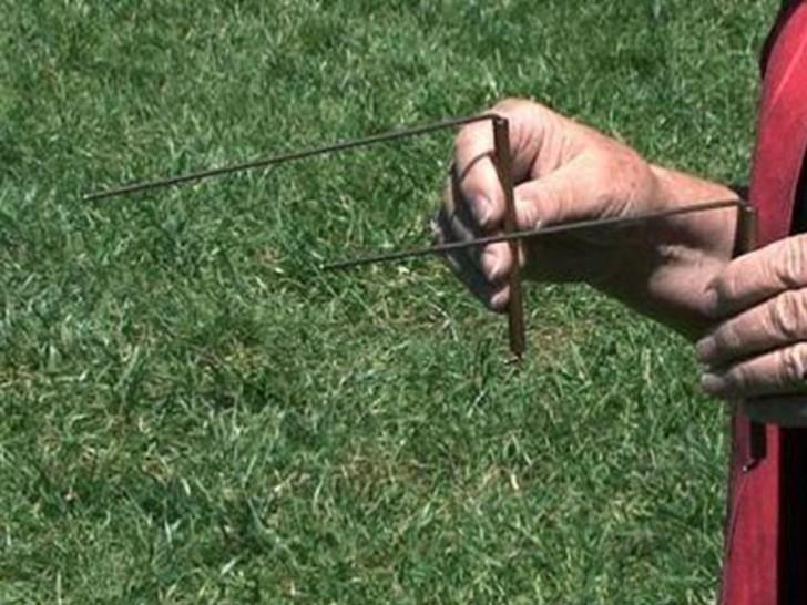
The location of the aquifer can be determined by dowsing using an aluminum frame or willow vine. The procedure for the aluminum frame is as follows:
- two forty-centimeter pieces of wire are bent at a right angle, as in the photo, and placed in a hollow tube so that they can rotate freely in it;
- having turned the ends of the wires in different directions and taking the tubes in hand, we begin to move along the site;
- in the place where the ends of the wire converge, there is an aquifer;
- the control passage of the section is carried out in a perpendicular direction.
The manipulations when using a willow frame are similar. This method is called dowsing and is as follows:
- a branch is cut from a willow with a fork of approximately one hundred and fifty degrees;
- the vine is thoroughly dried;
- when passing through the site, the vine is taken in hand so that the trunk is directed upwards;
- in the place where it goes down, there is water.

The most reliable is to conduct exploratory drilling
The most reliable method of detecting water on the site is to conduct reconnaissance drilling on it.
Using a conventional drill, several meters of rock are passed before colliding with the water horizon. Before you start digging a well, you need to send a sample of it for analysis to determine the presence of harmful impurities in its composition. 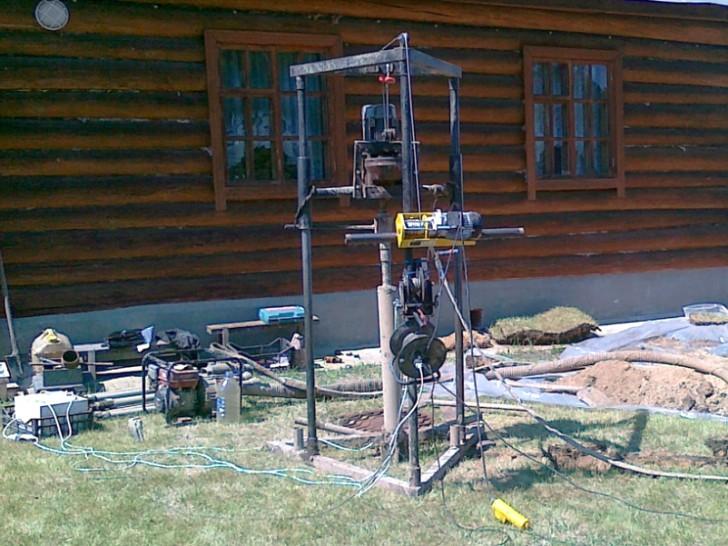 Compact drilling rig for private use
Folk method - arrange pots and jars
The folk method of searching for water on the site is carried out using glass jars and clay pots. In the evening, ordinary glass canning jars or pots are placed upside down throughout the site. In the morning they are carefully examined. The containers, at the bottom of which the largest amount of condensed moisture has collected, will indicate the location of the water vein.

Method for finding water by measuring the mass of hygroscopic materials
Moisture-absorbing material, such as ordinary table salt, is placed in identical clay pots. Pots of salt are weighed and buried in the ground evenly throughout the site. They are then dug up and weighed again. Those of them who received the greatest weight gain will show the location of the water.
The use of a barometer and other instruments is serious
A device such as a barometer, which can measure atmospheric pressure, will allow you to determine the depth of the water vein if there is a river, lake or other body of water near the site and, thus, help answer the question: how to find water for a well?
Atmospheric pressure is measured at the site and on the shore of the reservoir. Then you should remember from the school physics course that one millimeter of mercury corresponds to a height difference of thirteen meters and compare the measurement readings. If the difference was half a millimeter of mercury, then the aquifer is located at a depth of 13/2 = 7.5 meters.
We hope that the above information will help you find crystal clear water on your site. The following video sets out the authoritative opinion of a hydrologist on this issue.
How to find water with a frame
Very often, the search for water for a well is carried out using dowsing, an old and very accurate method for determining the watercourse. Before starting the search, you will need to prepare frames, which are pieces of aluminum wire about 40 cm long. Their ends at a level of about 10 cm are bent at a right angle. It is believed that it is best to insert frames into tubes of elderberry that have been cored. The wire in the tubes must turn absolutely calmly. Also, forks of branches of viburnum, willow or hazel can be used as a frame.
Frames are small pieces of aluminum wire bent at right angles.
- We determine the position of the cardinal points using the compass and mark them on the territory of the site with pegs.
- We take a frame in each hand. We press the elbows to the sides, we direct the forearms parallel to the ground, so that the frame becomes, as it were, an extension of the arms.
- Slowly we cross the territory of the site from north to south, and then from east to west. In a place where there is a watercourse underground, the frames will begin to move and intersect. This place is marked with a peg.
- Considering that water usually lies in the form of peculiar veins, having found one point, we determine the entire watercourse. To do this, we perform the previous operation several times, each time marking with a peg the place where the frames intersected.
We determine the power and depth of the watercourse. We imagine that we are diving to the depth of our own growth, then to two, three or more such distances. The first time the frame will react to the upper border of the water vein, the second - to the bottom.
A well on the site is a practical solution for providing water supply to the house and personal plot. Methods for self-search of an underground watercourse will determine the presence of water on the site and help make a decision on the possibility of arranging the system. But do not rely too much on them, because all these methods, although considered quite accurate, give only general answers to questions. Only specialists will be able to determine the presence of an aquifer, its depth and thickness absolutely accurately.
Building a well is the surest way to provide a summer cottage or a country house with a source of water that can be used both for drinking and domestic needs, and for watering garden plantings. This process is simple, and if there are several working hands, it can be carried out on its own. It remains only to understand how to find water for the well in such quantity on the site that it is enough to meet all the needs of the family.